
See where the plume is headed before you reach the scene.
LR-x® runs the ALOHA plume model over a 3D wind field from a phone or tablet, using weather from the nearest station. The first model is ready in under 5 minutes. Three forecast models follow, one completing about every 2 minutes.
Developed by the U.S. Army Research Laboratory as L-REAC™ and licensed exclusively to Diamond B Technology Solutions, LLC. U.S. Patent 9,911,303.
What is LR-x®?
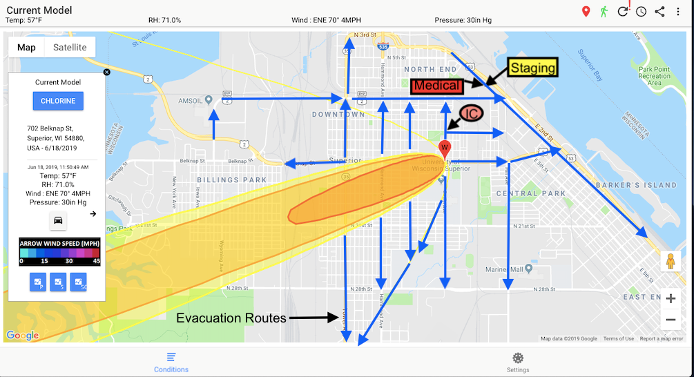
LR-x® is cloud-based software that shows where an airborne chemical, CBRN or smoke plume is likely to travel. It combines the NOAA/EPA ALOHA dispersion model with a 3D wind field model developed by the U.S. Army Research Laboratory, and draws both on a map you can use on a phone, tablet or computer.
Hazmat teams use it to set the command post, muster points and evacuation areas before arrival, then keep the picture current as the weather changes. All live and training runs are saved for after-action review.
- Runs on
- iPhone, iPad, Android phones and tablets, laptops and desktops (web)
- Plume model
- ALOHA (NOAA/EPA), maintained in the cloud, with CAMEO Chemicals data
- Chemicals
- Any chemical ALOHA can model: 500+ pure chemicals and common solutions, including H2S and chlorine
- Wind model
- Patented 3D wind field over terrain from ARL, 5 m and 50 m resolution
- Weather
- Nearest public weather station automatically, or your own WEATHERPAK® on scene
- Speed
- First model in under 5 minutes; three forecast models, one about every 2 minutes
- Threat zones
- Red, orange and yellow AEGL zones in ppm, tap for distances
- Terrain
- About 80% of the world (all but the extreme polar regions) from NASA SRTM; USGS 1 arc-second elevation for the U.S. and territories; LIDAR import
- Facility data
- About 60,000 EPCRA Tier II chemical facilities with contacts, updated monthly
Deploy, assess, communicate
- En route
Deploy
Type the address or drop a pin, pick the chemical and release details, and send the model from the truck. LR-x® finds the closest weather station on its own.
Deploying a model - Arrival
Assess
Read the threat zones over road, satellite or terrain views, with color-coded wind speed and streamlines. Forecast models show how the zone will move.
Reading the results - Throughout
Communicate
Everyone on the incident sees the same model on their own device. Police and the EOC get a share link that needs no account or app.
Sharing a model
What your crew sees

Threat zones you can act on
Tap anywhere inside the plume to see the chemical, the wind and the distance to each Acute Exposure Guideline Level.
- Red: life-threatening health effects or death
- Orange: irreversible or long-lasting effects, or impaired ability to escape
- Yellow: not disabling, reversible once exposure ends
Know what's stored next door
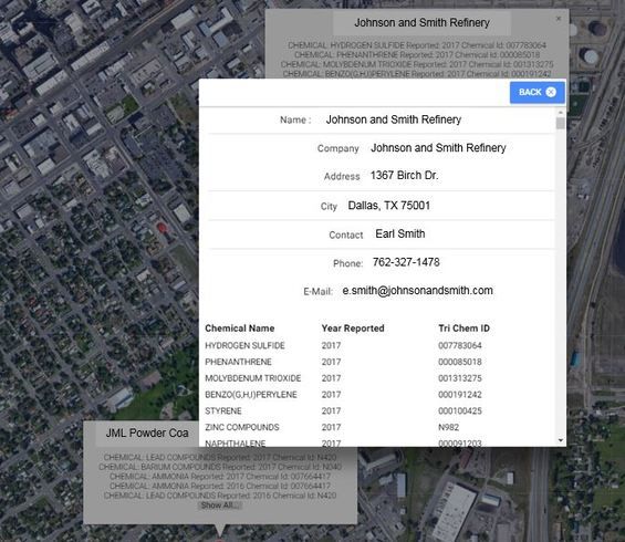
About 60,000 EPCRA Tier II reporting facilities appear on the map with contact names and numbers, updated monthly. One tap shows what chemicals a site has reported.
CAMEO Chemicals is one click away for chemical properties, response recommendations and the NIOSH Pocket Guide.
Wind that follows the terrain
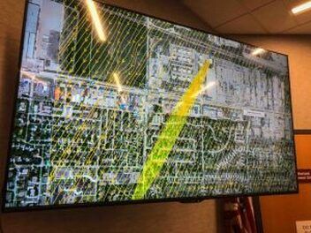
A single station reading gives one speed and one direction for the whole area. LR-x® runs a U.S. Army Research Laboratory 3D wind field model over USGS and NASA elevation data instead, so it shows where ridges and valleys turn and speed up the wind, and where buildings create eddies that hold a plume. That matters when you pick entry and exit routes.
Each run gives a 5 m and a 50 m wind field, and both can be exported as KML for ArcGIS along with the plume and forecast models.
Built for the people who respond
Hazmat teams
Run ALOHA plume models over a 3D wind field from a tablet while en route, and arrive with a threat zone already on the map.
Fire departments
Give company officers and incident commanders the same plume picture on their phones, with no desktop software to maintain.
Rail
Use existing weather sensors to see wind over complex terrain day to day, and model a release before first responders reach a derailment.
Industrial facilities
Pair LR-x® with fixed weather sensors around your facility so your industrial hazmat team sees how current and forecast weather will carry a release.
Military and CBRN
LR-x® began as the Army Research Laboratory's L-REAC™ system, built to protect soldiers and civilians from airborne hazards.
Wildfire
See how wind moves over mountains and valleys and track dangerous smoke, the job the system did during the 2011 Abrams Fire.
Public venues and training
Fixed sensors around a venue connected to LR-x® give officials a live wind field and a realistic way to train for a release.
Where LR-x® fits: by facility type
Used on real incidents
- 2011Abrams Fire, White Sands, NM. ARL's L-REAC™ system supplied wind fields to fire departments and the BLM for three days. Decisions not to evacuate, and when to set a backfire, were based in part on its output. Case study (PDF)
- 2017Fargo, ND Fire Department signs an LR-x® early adopter agreement.
- 2018Magellan terminal fire, West Fargo, ND. LR-x® had a plume model running within five minutes of a 30,000-barrel tank fire, helping plan possible evacuations. Read the Magellan fire story · Tank farm and terminal modeling
- 2018Billings, MT Fire Department joins as an early adopter.
The LR-x® plume modeling system is a significant advancement in threat zone management that every hazmat team should have in their arsenal.
Army research, put in a responder's hands
In the first decade of the 2000s the U.S. Army Research Laboratory ran three urban atmospheric field studies at White Sands Missile Range, New Mexico, examining airflow and stability around buildings. Emergency response drills run alongside the final study showed that responders needed real-time atmospheric data at their fingertips. ARL built the Local-Rapid Evaluation of Atmospheric Conditions system, L-REAC™, to provide it.
In 2017 Diamond B Technology Solutions, LLC licensed the system exclusively, renamed it LR-x®, and has kept working with ARL since. The technology is covered by U.S. Patent 9,911,303, "System to Evaluate Airborne Hazards," issued March 6, 2018.
See LR-x® run on a real incident location
We will walk your team through a live model for an address in your response area. Or start a 30-day free trial and run it yourself.